



Digital Twins & Interactive 3D: From Reality Capture to Immersive Experiences
Imagine exploring a real historic building, an industrial site or a property development as an interactive digital space. Instead of following a fixed video, users choose where to go, inspect places and objects, and access information at the exact location where it matters. This is the practical promise of interactive 3D and spatial digital twins.
Fourthedesign develops real-time 3D experiences, web-based spatial applications and VR simulations for clients in Greece and internationally. This guide explores how physical environments become interactive digital experiences, what distinguishes them from live operational digital twins, and what a real heritage project in Crete reveals about the production process.

What Are Spatial Digital Twins and Interactive 3D?
An interactive 3D environment is a digital representation of a space in which users can move, change viewpoints, select objects and discover contextual information. The environment may be created from architectural drawings, BIM and CAD files, hand-built 3D assets, photographs or reality-capture data. An interactive experience can exist entirely for visualization or communication without receiving live data.
A spatial digital twin represents a real place with organized geometry and associated spatial information. An operational digital twin connects a representation of a physical system with relevant real-world data and updates that relationship as required. Live sensors, telemetry and analytics are not automatically present in a photorealistic 3D tour. That distinction is important when evaluating project scope, accuracy and cost.
The Fourthedesign Digital Twins & Interactive 3D service focuses on accessible spatial visualization, realistic environments and purposeful interactions. For the broader definition and examples of operational twins, see our Digital Twins explained guide.

How Does a Physical Place Become an Interactive Digital Environment?
The workflow begins with the experience rather than the software. The team must understand who will use the application, what they need to discover, what level of visual realism is necessary, and whether the project requires accurate geometry, asset information, simulations or live operational data.
1. Plan the User Experience
A museum visitor may need guided viewpoints and historical interpretation. A property buyer may need a masterplan, building selection and unit information. A technician may need equipment records and service procedures. Those very different goals lead to different navigation systems, information structures, asset requirements and performance targets.
2. Prepare the Source Material
Available material can include photographs, drone footage, CAD/BIM models, photogrammetry, laser scans and conventional polygon geometry. Each source has strengths and limitations. Visual reconstructions can offer convincing appearance, whereas engineering tasks may need verified measurements and editable objects. Camera coverage and source quality affect reconstruction results.
3. Build and Optimize the Scene
Source assets must be organized, scaled and optimized for the intended device. A desktop workstation, browser-based platform, mobile phone and standalone VR headset differ in memory, graphics performance and interface requirements. A realistic experience that loads too slowly is not a successful solution.
4. Add Useful Interaction
Navigation points, guided tours, hotspots, interactive maps, selected objects, searchable information, audiovisual content and optional dashboards transform a passive environment into a useful application. Each feature should support a real task, rather than exist purely as decoration.
Real Fourthedesign Project: Four Historic Monasteries in Crete
Our cultural heritage work provides a concrete example of reality capture, 3D Gaussian Splatting and Unity VR integration. Fourthedesign captured drone imagery of the historic monasteries of Apezanon, Odigitria, Varsamonero and Vrontisi in Crete. The footage was used to reconstruct four photorealistic scenes of the buildings and their surroundings.
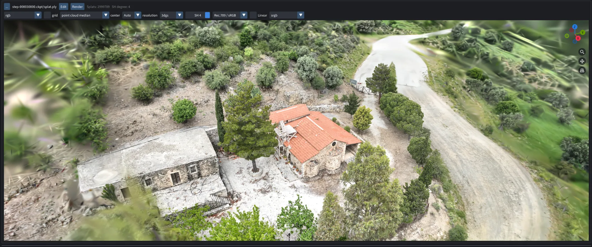
The four digital scenes were integrated into an interactive Unity virtual reality application, where visitors can experience the locations as immersive visual environments. This is a different form of engagement from watching a video or scrolling through a photo gallery: navigation and interaction help users understand architecture and spatial relationships in context.
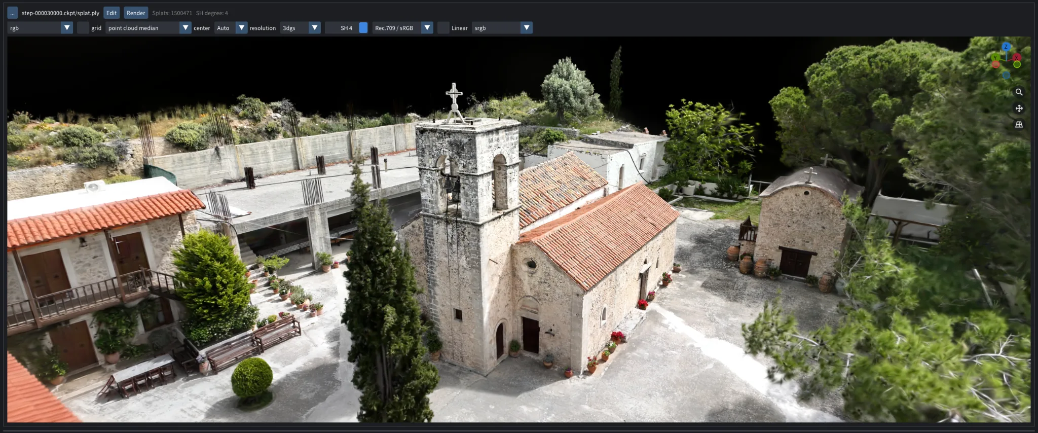
This particular project is an image-based spatial reconstruction and immersive experience, not a certified architectural survey, editable BIM dataset or a continuously synchronized sensor-based digital twin. Where a customer needs precise measurements, engineering geometry or current asset monitoring, complementary methods and validated data are essential.
See the full portfolio case study: 3D Gaussian Splatting & Interactive VR of Historic Churches in Crete for authentic project images and further details.
3D Gaussian Splatting vs Photogrammetry, Polygon Meshes and BIM
3D Gaussian Splatting uses photographs to reconstruct the appearance of a real scene with spatially positioned visual elements. It can be particularly effective for complex historic architecture and outdoor environments, where photorealism matters and manual modeling would be time-consuming.
Traditional photogrammetry meshes and polygon models can offer geometry suitable for many interactions and editing operations, depending on quality and capture. CAD/BIM models organize building information and geometry for design and technical workflows. These are related but not interchangeable production outputs.
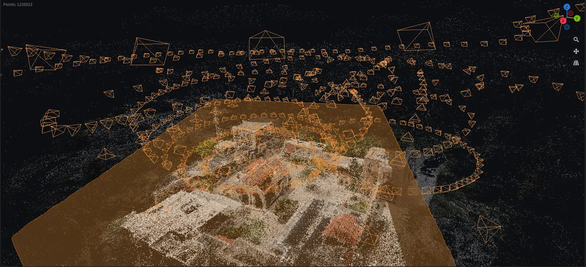
A captured Gaussian Splatting scene alone does not guarantee dimensionally accurate measurements, collision behavior or editable components. A hybrid workflow may combine image-based scenery with conventional 3D meshes, interactive objects, information points or BIM data. The intended use should determine the method—not whichever technology happens to be fashionable.
Where Can Interactive Digital Spaces Create Business Value?
Architecture and Real Estate
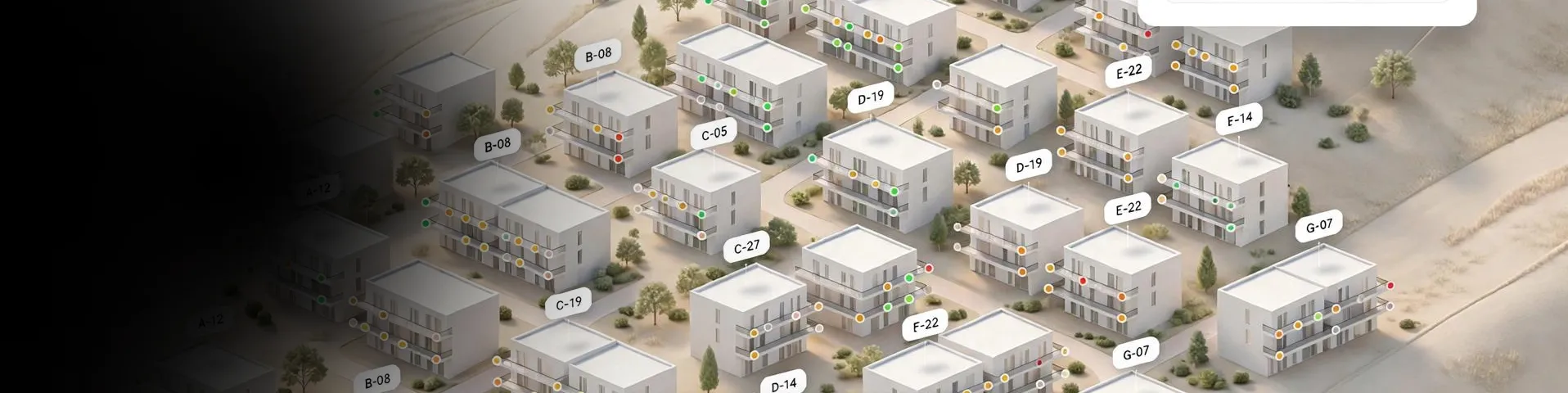
In architectural visualization, users can investigate buildings, understand site layouts and explore a project before construction. In property sales, an interactive application can attach availability, floor plans, images and specifications to specific units. The ENIGMA interactive Web 3D property explorer demonstrates Fourthedesign’s approach to browser-based navigation and spatial information.
Industry and Facility Operations
Technical teams can use spatial visualization to explain a plant layout, identify machines, attach documents to locations and support training. Where an organization has the necessary infrastructure, an application may also connect with selected databases, IoT devices or operational dashboards. These integrations need separate planning, access control and verification.
Cultural Heritage and Tourism
Historic buildings may be difficult to access, fragile or widely distributed. Reality capture and immersive presentation can provide an additional digital way to experience architecture and landscapes. Visitors can follow guided paths, access contextual media and learn about locations in an engaging format without claiming the digital version replaces the physical site.
Education and Workforce Training
Real-time environments can demonstrate technical sequences or support scenario-based VR exercises. The C-MineTech industrial VR training project is a related example of immersive technical education and circular-economy workflows. It is important not to equate every training simulation with a live-connected operational twin.
Web 3D, Mobile, Desktop or VR?
Web 3D supports accessible experiences through modern browsers, often without installing a separate application. Desktop applications are useful for more demanding environments and controlled hardware. Mobile applications require careful optimization and touch-friendly interfaces. VR creates stronger immersion for guided exploration and practice, while introducing device, performance and comfort considerations.
A large scene with high-fidelity reconstruction may require different delivery strategies than a lightweight browser viewer. A sensible project brief defines the target audience, expected devices, network conditions, accessibility needs and update process before choosing the stack.
How to Scope a Useful Interactive 3D Project
Organizations should begin with a clear inventory of existing materials, locations, desired interactions, stakeholders and success criteria. Decide whether the goal is visual presentation, structured asset information, training or an operationally synchronized twin. Specify whether distances need certified precision. Identify which data can be made available, who can maintain it and who is responsible for security.
For a phased project, a first demonstration can validate a representative scene, navigation approach, user tasks and device performance. Further areas, backend functions or data integrations should follow after that foundation works. This keeps costs predictable and reduces the risk of a beautiful but impractical result.
Frequently Asked Questions
Is every interactive 3D application a digital twin?
No. The terms describe different aspects of a system. Interactive 3D is a visual and interaction layer; a meaningful digital twin has a defined relationship to a real entity and relevant information, with operational synchronization when required.
Can Gaussian Splatting be used inside VR?
Yes, with an appropriate rendering and performance workflow. Fourthedesign’s historic monastery project demonstrates integration of captured Gaussian Splatting scenes into a Unity VR experience.
Can these experiences run in a web browser?
Many can, depending on dataset size, interaction scope, graphics hardware and network conditions. Performance targets should be established during technical planning.
Is Gaussian Splatting suitable for measurements?
A visually realistic scene is not automatically a measurement-grade survey. Verified geometry and calibration are needed for tasks that depend on reliable dimensions.
Can we add live data later?
Potentially, if the architecture and rights to access source systems permit it. Data relationships, security and maintenance should be designed explicitly rather than assumed.
How much will an interactive spatial environment cost?
The cost depends on capture scope, content quality, number of locations, performance targets, interactive functions, deployment platforms and any data integration or ongoing support. A focused pilot provides a practical basis for an estimate.
Build a Useful Digital Experience with Fourthedesign
Fourthedesign combines real-time 3D production, interactive experience design, VR development and visual reconstruction expertise. For cultural sites, architecture, industrial presentation and training, we work from the real purpose of the project rather than promising every technology under one label.
Explore our Digital Twins & Interactive 3D service, discover the historic Cretan churches case study, or contact Fourthedesign to discuss your space, source material, audiences and goals.

